|
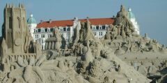
June-July-August 2002 France-Monaco-Belgium-The Netherlands
8 Days
In the
Kingdom of Belgium
Backroads, By Car
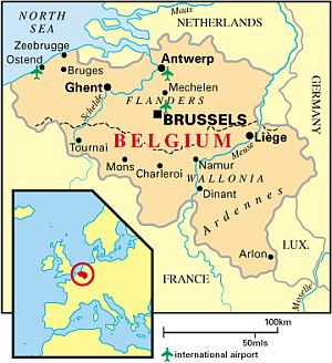
WALLONIA
FLANDERS
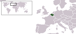
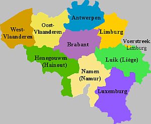
Belgium is a European nation of 11 million people, divided in half both linguistically and geographically. Vlaams (Flemish), a Dutch dialect, is spoken in VLAANDEREN (Flanders), the flat northern lowlands that border the Netherlands. French is spoken in WALLONIE (Wallonia), the elevated, hilly, southern region that borders France. The capital city of Brussels is an officially bilingual enclave. There is also a small minority population of 70,000 German speakers along the German border to the east.
The government is a parliamentary democracy with a constitutional monarchy. The dominant religion is Roman Catholicism, practiced by 75% of the population. Belgium has existed as a nation-state since 1831, when it broke away from the Netherlands. The European Union and NATO both keep their headquarters in Brussels.
Belgium is celebrated for its painters, its architecture, its beer, and its chocolate.
Belgium's Regions
VLAANDEREN (Flanders)
Flanders is the name given to the northern half of Belgium. The name once belonged to a county, now formally divided into the two provinces of Oost-Vlaanderen and West-Vlaanderen, but Flanders on its own refers to a much wider area, incorporating the provinces of Oost-Vlaanderen, West-Vlaanderen, Antwerpen, and Limburg, and Vlaams-Brabant.
The primary tongue in Flanders is Flemish, a dialect of the Dutch language spoken in Belgium's northern neighbor, the Netherlands. Most of Flanders is flat and low-lying. The largest cities are Antwerp, Gent, and Brugge.
WALLONIE (Wallonia)
Wallonia is the southern half of Belgium, comprised of the provinces of Hainaut, Namur, Liege, Luxembourg (province, not the country), and Brabant Wallon. The dominant language is French, save for a small enclave at the far eastern corner of the Liege province where German is spoken.
In contrast to the flat terrain of Flanders, Wallonia is undulating, with rolling hills, high plateaus, and serpentine river valleys which gouge deep troughs into the countryside. Wallonia is home to approximately thirty percent of Belgium s population of ten million; the largest cities are Liege and Charleroi.
Brabant
The borders of the lands known as "Brabant", located roughly in the center of modern Belgium, have grown and shrunk over the centuries. "Brabant" was once a Dukedom, and as the political power of the Dukes of Brabant waxed and waned, so did the size of "Brabant".
For much of the history of the Belgian nation since the Revolution of 1831, Brabant was a single unified province with fixed borders. In the late 20th century, however, the province of Brabant are divided into three parts: the provinces of Vlaams-Brabant and Brabant Wallon, and the administrative area of Brussels.
Vlaams-Brabant (Flemish Brabant)
If you look at a map of Belgium, it would seem that Belgium's capital of Brussels dominates the province of Vlaams-Brabant -- however, Brussels is officially an independent entity, and not a part of the province which surrounds it on all sides, so Vlaams-Brabant has a large hole carved out of its center. The provincial capital of Vlaams-Brabant is not Brussels, it is the university town of Leuven. The area around Brussels is heavily urbanised. To its northeast lie the gentle rolling hills of the Hageland. In the southeast, the Hageland gives way to the farming region of the (Page Missing). In the southwest are the plateaus of the Pajottenland. The Ijse River rises near Brussels and flows through Leuven on its way north.
Brabant Wallon (Walloon Brabant)
French-speaking Brabant Wallon, is the southern third of the former province of Brabant, which was carved up in 1995. It is the smallest Belgian province, both in surface area and population.
The suburbs near Brussels are dense and sprawling, encompassing the historic town of Waterloo and the reaching all the way to the outlying city of Wavre, which serves as the capital of Brabant Wallon. Technology firms have a major presence in Brabant Wallon, especially around Brussels and in the university town of Louvain-la-Neuve. The east and west corners of the province remain largely rural, alternating farmland with large wealthy estates.
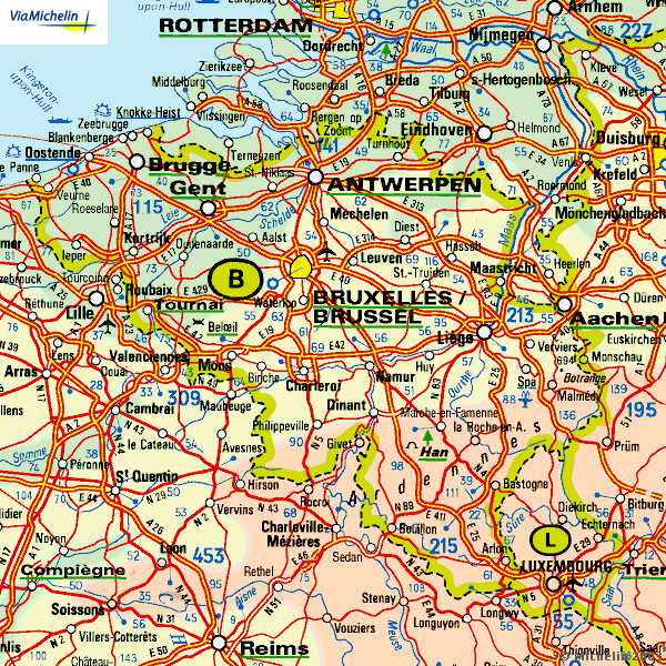
Brussels (Fr: Bruxelles; Nl: Brussel)
Brussels is the largest city in Belgium, with over a million residents including the greater metropolitan area. It is located on the Senne river near the center of the country, within the province of Vlaams-Brabant -- however, it is not officially part of Vlaams-Brabant, but its own administrative entity.
Brussels is officially bilingual -- both French and Flemish are spoken, with French being more prevalent. It is common to find people speaking other languages as well, for Brussels is a cosmopolitan, international city, home to the headquarters of NATO, and to most of the important institutions of the European Union.
The center of Brussels is the oldest part of the city, while the outer neighborhoods have a more contemporary feel. The northern and western boroughs are home to industry, while those in the south and the east are residential. Brussels has a vast array of first class cultural activities and institutions; it is particularly well known for its art museums.
Belgium's Natural Features
Condroz
The Condroz, a region in central southeast Belgium, is bordered on two sides by the Meuse River and on a third side by the Ourthe River. Limestone, sandstone, schist, and clay are the primary components of the Condroz soil, and there are several caverns carved out through solid limestone hills by rivers that duck briefly beneath the surface, including the famed Hotton Caves. Most of the land is occupied by farms and forest.
Gaume
Gaume lies in the southermost reaches of Belgium, at the tip of the Luxembourg province. The Gaume region is a sub-region of the Ardennes. Virton is the capital. The influence of French culture upon this border zone is profound, reflected in everything from the architecture to the peculiarities of the local dialect.
Hageland
The Hageland (literally, hedge country) is an area of rolling hills in the northeast corner of the Vlaams-Brabant province, comprising 30 or so municipalities and bordered by (Page Missing) and Diest. The hills are actually the remains of beaches left behind by the receding sea. The reddish-brown sandstone mined in the area is a key characteristic of Demer Gothic architecture, so named for the river that flows through the region. In the south, near (Page Missing), the Hageland abuts the Haspengouw farming region.
Haspengouw
The Haspengouw, as it is called in Dutch, or Hesbaye, in French, is a fertile farming region, spread over gentle hills and valleys. It is often called the Fruitbasket of Belgium, especially around the towns of Sint-Truiden (known for its cherries) and Zoutleeuw.
The Haspengouw is spread over five provinces: the eastern portions of Vlaams-Brabant and Brabant Wallon, the north of Namur, the west of Liege, and the south of Limburg.
Hautes Fagnes
The Hautes Fagnes region is a plateau at the far eastern end of Belgium, stretching from Malmedy and Butgenbach in the south to Eupen in the north. It is desolate and largely uninhabited, and has inspired many poets and painters with its open landscape. Much of the area is now a nature preserve. It is popular with both hikers and cross-country ski enthusiasts.
Lesse River Valley
The winding Lesse River Valley is popular for canoe and barge trips. Most excursions take you along the 21 km route from Houyet to Anseremme, passing exquisite scenery and numerous leisure and food stops. The Furfooz National park is the most attractive part of the trip.
Maasland
The Maasland is a narrow stretch of land in the vicinity of the Meuse River, for which the Dutch name is Maas. Unlike the Kempen region immediately adjacent to the west, the Maasland is fertile and lush. The Meuse has changed its riverbed several times over the millenia, leaving behind a rich and varied landscape.
Meetjesland
The Meetjesland region is an area of flat lowlands north and west of Gent, extending to the Dutch border on the north. To the west of the Meetjesland lie the reclaimed lands of the Polders.
Midden Limburg
Midden Limburg is heavily developed in the vicinity of Genk and Limburg's provincial capital, Hasselt; but outside the industrialized area you will find the 1359 acre Bokrijk Estate and its 222 acre open air museum.
Pajottenland
The Pajottenland lies southwest of Brussels and its suburbs. The terrain is hilly, with numerous streams. The primary economic activity is farming, but the Pajottenland is mostly famous for its Lambic beers, of which there are several brewers in the area.
Polders
The dictionary definition of Polders indicates lowlands, typically reclaimed from the sea through drainage and protected by dikes. The most extensive region of polders in Europe is in the Netherlands, and indeed the word "polder" is of dutch origin.
West Flanders is very similar in its terrestrial character to the Netherlands. Much of it is made up of reclaimed land protected by dikes, and it is this region that is referred to as The Polders of Belgium. The land is fertile and an area of intense agricultural activity. Like the polders in the Netherlands, the sea yearns to reclaim the territory for itself. Catastrophic floods inundated the area in 1953, due to North Sea storms that overwhelmed the dikes. In 1915, the area near Nieuwpoort was intentionally flooded to stop the advance of the German army.
Tomb of the Giant
Botassart is a tiny village near Bouillon, with a grand vista overlooking the Semois River Valley. The most spectactular item within the field of view is the Tomb of the Giant (Tombeau du Geant), a heavily wooded peninsula formed by a tight turn of the Semois, with sloping sides that make it look as though a giant lies buried beneath.
Soignes Forest
Soignes Forest lies immediately to the southeast of Brussels. It covers 10,000 acres, and contains the remains of some old abbeys, numerous footpaths and bike trails, and countless beautiful old beech trees. Soignes is a remnant of the ancient Forest of Cologne which stretched over much of Belgium before it was developed.
Six Ourthes Vista
The Six Ourthes Vista is a tower constructed at a strategic spot on the Upper Ourthe River, which offers an impressive view of the twists and turns in the river valley below. There are so many cutbacks in the river, the extents of which are obscured from view, that there seem to be several seperate rivers -- hence the name.
--http://www.2hwy.com/be/homepage.htm
RELATED WEBSITES
 |
ILE-DE-FRANCE (periphery) France |
WALLONIA Belgium |
 | | |
|